


Even with the human civilisation climbing heights of progress, poverty remains a big global problem. With over a hundred crore people still suffering from poverty large-scale initiatives have met with limited success.
Many issues, such as dependence on data and surveys that are largely unreliable have hindered these attempts. Now a new model of mapping technique has been introduced that could bring an end to this problem.
The emergence of the new mapping technique was first reported in the 14th November edition of the ‘Proceedings of the National Academies of Sciences,’ the scientific journal published by the ‘National Academy of Sciences.’
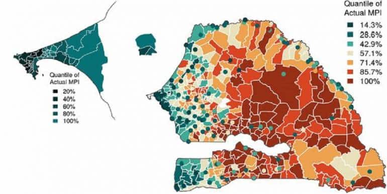
The report, which was titled as “Combining disparate data sources for improved poverty prediction and mapping,” gives a detailed information about how researchers are using mobile call records and records from geographic imagery to create poverty map of Senegal in a swift and efficient manner.
 Source: Proceedings of the National Academies of Sciences
According to the write-up by Neeti Pokhriyal and Damien Christophe Jacques, the new mapping was done by collecting and connecting two different data sets. The first one was collected by studying around 1100 crore phone calls that were made by countries 90 lakh mobile phone users. The anonymous information thus collected various details about the communications made by the people.
The second data set was collected with the help of images that were collected from satellite imagery, geographic information systems and weather stations giving information about food security, economic activity, and accessibility to facilities.
Using these two data sets, the researchers created maps that gave details about the poverty level of 552 communities in Senegal. This is a huge improvement when compared to traditional data collecting models. The global Multidimensional Poverty Index (MPI), which is based on old method, classifies country only into four large sections, the new method gives community level information about poverty in the country.
While the authors claim that the intention behind introducing the new technique is not to replace the traditional census methods, the new system can definitely supplement and improve the existing data collection methods.
Discover the latest Business News, Sensex, and Nifty updates. Obtain Personal Finance insights, tax queries, and expert opinions on Moneycontrol or download the Moneycontrol App to stay updated!

Find the best of Al News in one place, specially curated for you every weekend.
Stay on top of the latest tech trends and biggest startup news.


