


In the aftermath of a devastating landslide in Wayanad, Kerala, high-resolution satellite images from the Indian Space Research Organisation (ISRO) have unveiled the extensive damage caused by the disaster. The catastrophic landslide, which has claimed over 250 lives, highlights the severe impact of natural calamities in vulnerable regions.
The landslide, triggered by heavy rainfall, has significantly hampered ongoing rescue operations. The destruction spans approximately 86,000 square metres of land, with debris flowing nearly 8 kilometres along the Iruvaiphuzha River. The National Remote Sensing Center (NRSC) in Hyderabad deployed ISRO's advanced Cartosat-3 optical satellite and the RISAT satellite, capable of penetrating cloud cover, to capture detailed images of the devastation.
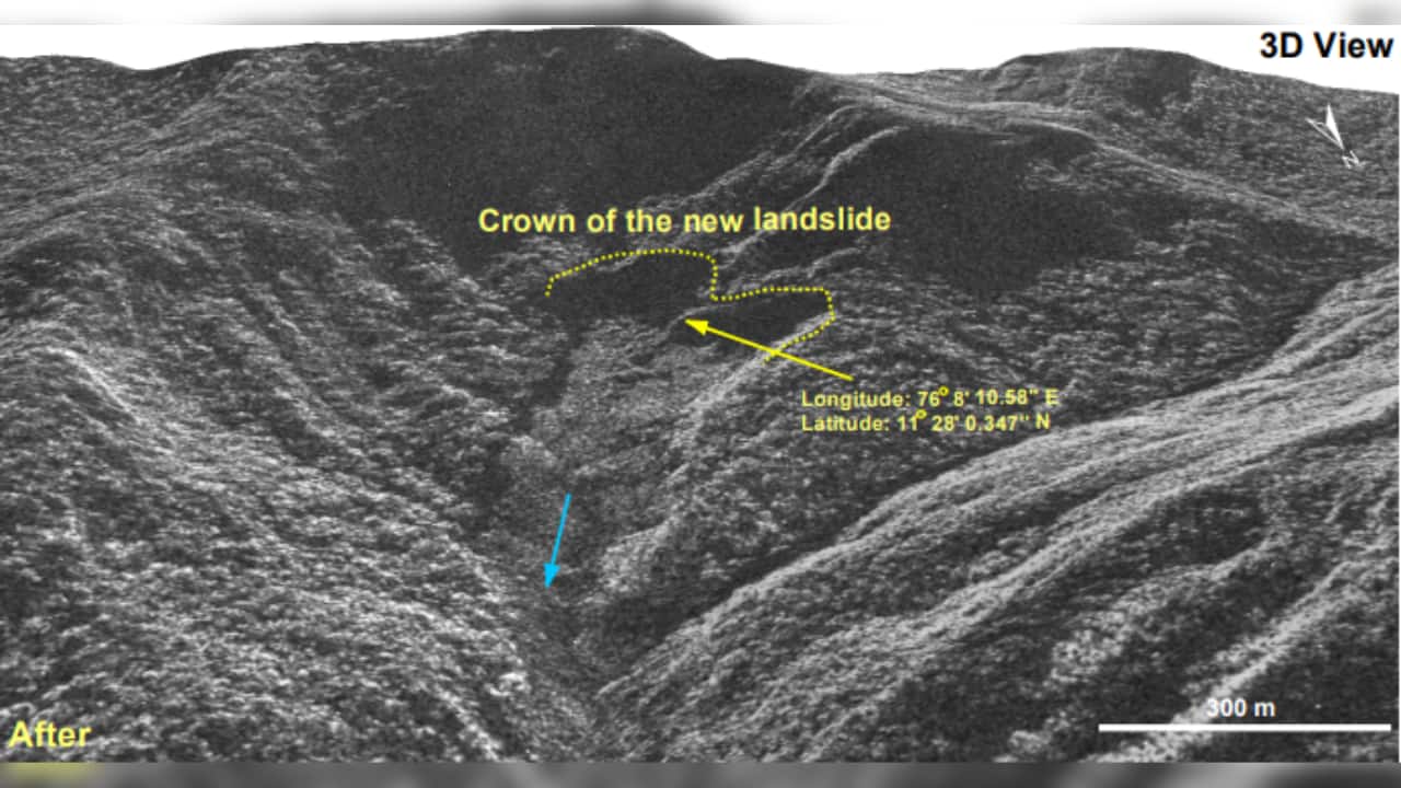 Photo Credit: NRSC/ISRO
The landslide originated at an altitude of 1,550 metres and has widened the river's course, causing extensive damage to houses and infrastructure along its banks. S. Abhilash, director of the Advanced Centre for Atmospheric Radar Research at Cochin University of Science and Technology (CUSAT), notes that a persistent monsoon trough off the Konkan coast has been driving significant rainfall in several districts, including Kasargod, Kannur, Wayanad, Calicut, and Malappuram, over the past fortnight.
The saturated soil, combined with a deep mesoscale cloud system formed off the Arabian Sea coast, led to extremely heavy rain in the affected districts. This resulted in localised landslides, exacerbating the already dire situation. Interestingly, satellite data also revealed the presence of an old landslide at the same location, emphasising the area's vulnerability to such disasters.
 Photo Credit: NRSC/ISRO
The NRSC report indicates that the landslide was intensified by a major debris flow initiated by torrential rains in and around Chooralmala town. The impact has been devastating, with entire villages flattened and many residents feared trapped under thick layers of mud.
Rescue teams, comprising Indian Army troops and National Disaster Response Force members, are working in a non-stop operation to deliver essential aid and rescue those stranded in the disaster-hit area.
The satellite images and data provided by ISRO are crucial for ongoing rescue efforts and future disaster preparedness. The images not only aid immediate rescue operations but also contribute to understanding the geological vulnerabilities of the region. This information is vital for informing future mitigation strategies and improving disaster response mechanisms.
The "Landslide Atlas of India," prepared by ISRO in 2023, had already identified Wayanad as a region vulnerable to landslides. The latest images and reports reaffirm this assessment, highlighting the need for enhanced monitoring and preventive measures. The atlas, which documents over 80,000 landslides that have occurred in India over 20 years, underscores the importance of preparedness in regions prone to such natural disasters.
Dr. S. Somanath, Chairman of ISRO, emphasised the significance of the Landslide Atlas in understanding the overall landslide scenario in India. He noted that the atlas would be beneficial to everyone involved in disaster management endeavours, providing valuable insights into landslide hazards.
As rescue operations continue, local officials are assessing the long-term implications of the disaster. The findings from the satellite imagery will play a crucial role in developing strategies to mitigate future risks and enhance the resilience of vulnerable regions.
The Wayanad landslide serves as a stark reminder of the destructive power of natural disasters and the importance of preparedness and resilience in the face of such events. The combined efforts of scientific research, advanced technology, and coordinated response teams are essential in managing the aftermath and reducing the impact of future disasters.
Discover the latest Business News, Sensex, and Nifty updates. Obtain Personal Finance insights, tax queries, and expert opinions on Moneycontrol or download the Moneycontrol App to stay updated!
Find the best of Al News in one place, specially curated for you every weekend.
Stay on top of the latest tech trends and biggest startup news.


