


What did the first nearly accurate map of India look like? How did the British set about painstakingly mapping this massive country even as they coveted and claimed large tracts of it as their own? What was the scale of this imperial project? One might have a fair idea of how all of this happened — thanks to John Keay, who wrote The Great Arc all those years ago — but Mapped, a new exhibition at the Asiatic Society of Mumbai, provides a deeper, more visceral sense of how cartography helped make colonial empires.
Curated by heritage management company Past Perfect, the exhibition unfurls a century of surveys undertaken by the British, including, of course, The Great Trignometric Survey (GTS), the numerous marine and eventually revenue and other administrative surveys.
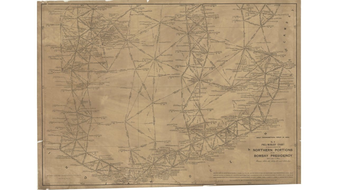 44E Gulf of Cambay triangulated: A Marine Survey Map of the Gulf of Kutch.
An entire story involving conquest, power play, and espionage plays out through the maps that belong to the Asiatic Library’s collection and are part of a larger Cartographic Conservation project that kicked off in 2019, says Deepti Anand, co-founder of Past Perfect. And it all started, in a way, with James Renell, who made the first nearly accurate map of India in 1788.
“Prior to this all maps of India look absurd, because people referenced the prime meridian in Paris or Greenwich. Renell, who was appointed the first Surveyor General of India, standardized the kos, the local unit of measuring distance. And since the British had gained control of Bengal back then, he was also able to assign a meridian in Calcutta for more accurate longitudinal measurements,” says Anand. In the 17th and 18th centuries, as colonial powers made their first inroads into India, maps of coasts were especially sought after. “We’ve displayed two such maps at the exhibition, but the Society has nearly 100 such maps. There are marine surveys of almost every river and port in the country, and people actually traded maps because a lot about India was then unknown,” says Anand.
The exhibition has a particularly interesting display of maps belonging to the remarkable GTS series, but equally interesting are the glimpses it provides into the lives of the men who laboured under the British on the over 100-year project that began in the late 1700s and, besides producing deeply accurate maps of their dominion, also measured the heights of several Himalayan peaks, including Everest, K2, and Kanchenjunga. So, while the efforts of ‘cartographer-spies’ such as Nain Singh and Radhanath Sikdar, who gave the British a sense of what lay beyond India’s borders, are rightly highlighted, you also have short extracts from surveyors’ diaries.
“Curating the exhibition got us into the headspace of the local guys who got this whole operation done. It was tedious, dangerous, backbreaking work, and there are episodes of loneliness, mental health issues, rants in these diaries that we went through,” says Anand. William Lambton, the man behind the GTS, wrote tomes on his plans and method of triangulation, some of which are on display at the exhibition along with some of the about 28 volumes of reports the surveying of each quadrilateral produced.
Many of the maps on display were donated to the Asiatic Society by the Bombay Geographical Society, and in them the visitor can see Bombay blooming and expanding. The Second Revenue Survey of Bombay, conducted in 1869 in association with the GTS, took over seven years to complete and surveyed some 21,000 properties. It also captured the visual and structural topographical changes the city was undergoing. “You had a lot of people coming in, there were roads and railway lines, agricultural land was being converted, these maps kind of capture the city on the cusp of a huge change,” says Anand.
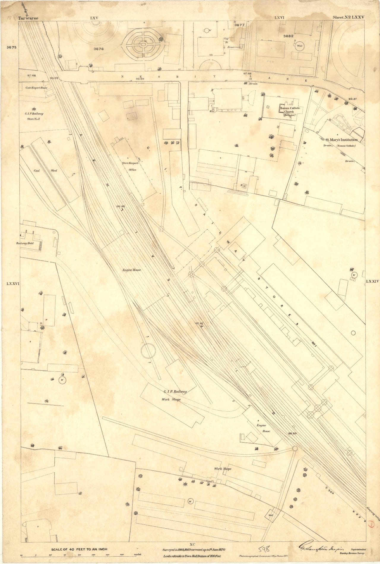 598-Tarwaree: A map showing part of Tarwaree in Bombay from the Second Bombay Revenue Survey conducted under Laughton.
Mapped: Surveys That Left behind a Legacy is on at the Asiatic Society of Mumbai until June 4.
Discover the latest Business News, Sensex, and Nifty updates. Obtain Personal Finance insights, tax queries, and expert opinions on Moneycontrol or download the Moneycontrol App to stay updated!
Find the best of Al News in one place, specially curated for you every weekend.
Stay on top of the latest tech trends and biggest startup news.


