


")
In the far blue of the Atlantic, a gentle giant is in peril. The North Atlantic right whale, one of Earth's most endangered mammals, still fights for survival. Now, scientists are turning to space technology to assist.
Whales' Survival Depends on Tiny Plankton Blooms
Though commercial whaling is banned worldwide, threats confront these whales. Ship collisions and entanglements in fishing nets are the greatest risks. In order to minimise such threats, researchers are resorting to smart tracking devices. Scientists need to know how and where whales forage.
They are fed by small reddish copepods named Calanus finmarchicus. They move in association with where these plankton are found. Scientists now use satellite imagery to chart out plankton hotspots. This is used to predict whale migrations along the Atlantic Ocean.
One of the main feeding grounds is the Gulf of Maine. The region experiences thick plankton blooms which the whales are drawn to. NASA utilises its Aqua satellite to assist in mapping copepod locations. Its MODIS sensor monitors alterations in how sunlight scatters off the ocean. It searches for astaxanthin, which is a pigment that gives copepods their reddish colour.
This colour alters light scattering in the water of oceans. When they cluster in groups, they also change the light signature. Researchers from space employ this signal to locate copepod swarms. This allows scientists to track the whales' cuisine—without invading the sea.
By interpreting these colour signals, researchers estimate the density of copepods. This makes for improved predictions of whale feeding grounds. Monitoring these shifts from space is quick and far-reaching. Scientists first tried this approach in Norway. They now use it to monitor North Atlantic right whale habitats.
By integrating satellite images, field observations, and sophisticated models, researchers receive clearer charts. They reveal patterns of copepod movements more precisely. Based on this information, scientists can better navigate shipping lanes and position nets.
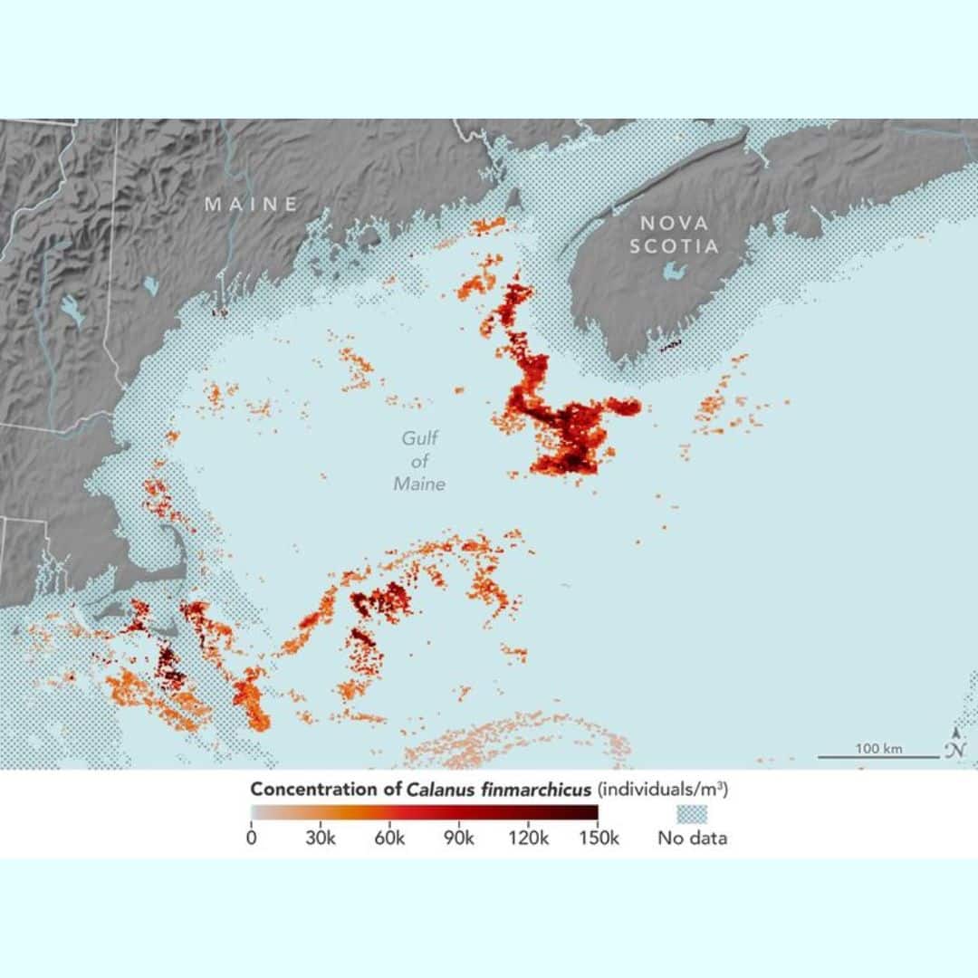 NASA satellite imagery from June 2009 was used to test a new method for detecting the copepod Calanus finmarchicus in the Gulf of Maine and estimating their numbers from space. (Image: NASA)
Nevertheless, the process has limitations. MODIS cannot visually detect the copepods. It could mistake other red sea creatures for copepods. Cloud cover and storms also degrade image quality. The moment that copepods move deeper, they become invisible.
To address these concerns, NASA is going to introduce the PACE satellite. PACE is short for Plankton, Aerosol, Cloud, and ocean Ecosystem. This satellite will deliver clearer, high-resolution images of plankton. It will be able to pierce through clouds and rough seas better.
PACE is being planned for a 2024 launch. It will provide better detection of zooplankton and phytoplankton. Scientists hope that it will support better whale conservation. The device, if utilised along with other techniques, might lead to improved findings in monitoring the whales' prey.
Hopes Rise for Right Whale's Future in Changing Seas
The North Atlantic right whale relies on its prey. By following copepod blooms, researchers receive crucial hints about the whales. With improved forecasts, there is hope to prevent ship strikes and net entanglements.
Despite weather and data difficulties, new technology holds new promise. NASA's next satellite may hold the key to saving these giants. As technology advances, so does the battle to save a species teetering on the brink.
Discover the latest Business News, Sensex, and Nifty updates. Obtain Personal Finance insights, tax queries, and expert opinions on Moneycontrol or download the Moneycontrol App to stay updated!
Find the best of Al News in one place, specially curated for you every weekend.
Stay on top of the latest tech trends and biggest startup news.


