


")
On June 18, past midnight, Ramesh, 67, woke up as water started gushing into his house on Netravati Main Road of Sai Layout in eastern Bengaluru. Along with his wife, Jayshree, 57, they started scooping the water out. Around 1 am, Jayshree slipped and fractured her right arm.
Incessant rainfall from June 17 led to the inundation of at least 400 houses in Sai Layout, Pai Layout and adjacent regions in KR Puram, and caused at least two deaths.
About a kilometre away, Kaveri Road residents said they have been facing the problem for the last two decades.
 Jayshree got her hand fractured after the night water rushed into her house (Credit: Souptik)Aren’t there proper warning systems?
The Karnataka State Natural Disaster Monitoring Centre (KSNDMC) has installed 134 water-level sensors in flood-prone areas throughout the city.
Says Dr Shiv Kumar, Scientific Officer and Hydrologist at KSNDMC: “We have collaborated with Space Application Centre, Ahmedabad, and Indian Space Research Organization (ISRO) to receive daily forecasts. This has been in place for five years now,” he said.
“Based on the data, we are running the Urban Flood Modelling project. The water sensors relay live data and we quickly send out alerts keeping a 24-8, or two-hour window at the minimum,” he said.
“The data can be analysed to calculate the severity of floods. This can aid in the evacuation of people. However, a number of other agencies like the BBMP, or the Bengaluru municipal corporation, have to act upon the alerts," Srinivasa, a researcher and water consultant, said.
 Residents nearby have started redesigning their drains to prevent water flowing into their homes (Credit: Souptik)Is the BBMP not following up on the alerts?
M Lokesh, Chief Engineer at BBMP (Stormwater Drain), explains how the system works. “We already have zonal control rooms in the city. During rainy seasons, we form a task force at the sub-division level. The city’s drainage system, he said, is designed to handle 70 mm of rain per hour. Anything in excess will lead to flooding. We can only control the damage. We cannot prevent flooding.”
Agrees Dr A Ravindra, former chief secretary and former chairman of Bangalore Development Authority (BDA): “Even a good forewarning system cannot control flooding. Before these designs came into place, we didn't experience this degree of flooding. We have to design the city in a manner that flooding can be prevented. The prevention aspect has failed due to design defects.”
What then is the way out?Dr TV Ramachandra, a scientist at the Indian Institute of Science, cites the case of KR Puram, where the recent flooding was heavy. Though water sensors were present in the area, most drains and lakes were encroached.
Though we received the alerts, we could not divert excess water, he said.
The BBMP has identified at least 211 flood-prone areas, including 58 critically vulnerable. The Karnataka government, in January, had granted Rs 1,500 crore to remodel 158 km of storm water drains in the city's peripheral areas. This was in addition to Rs 972 crore already granted.
However, as Lokesh says, if alerts can only minimise the damage, and nothing beyond, what options do the government have?
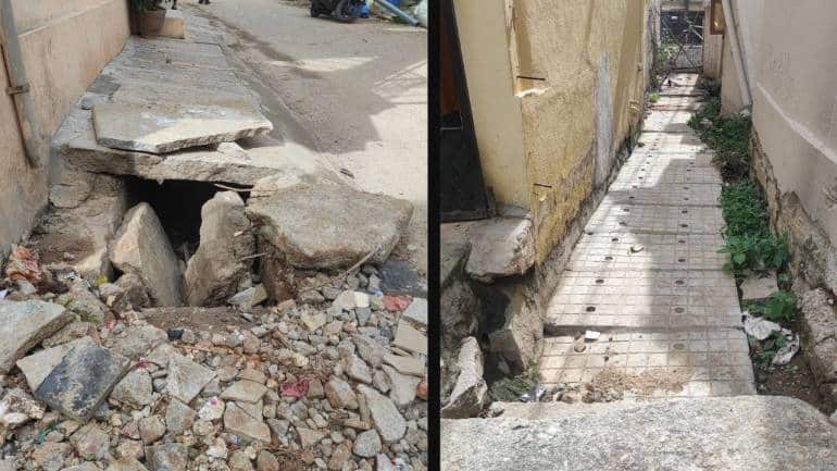 Stormwater drains in the area obstructed by debris or encroached by houses (Credit: Souptik)Traditional culprits
Despite all the technological aids and scientific studies, it all boils down to that two old culprits – urbanisation and encroachments.
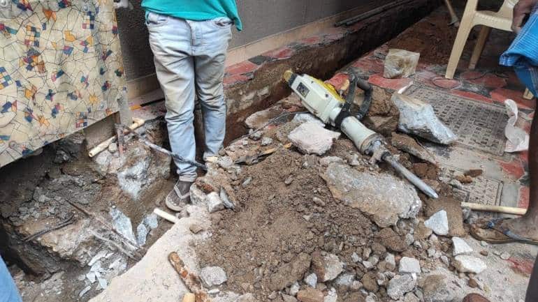
At least four storm water drains Moneycontrol observed across Sai Layout have been encroached by buildings or have been clogged by silt and debris.
Encroachment of storm water drains, against the National Green Tribunal (NGT) guidelines of 5-50 metres around the drains, has increased multi-fold across the city.
The Karnataka government had told the Supreme Court that if the NGT’s 2016 directions concerning buffer zones around lakes and storm water drains were to be implemented, at least 95 percent of buildings in Bengaluru have to be demolished.
The Bangalore Development Authority (BDA) Master Plan 2015 is also not sufficient to address these issues, says Raj Bhagat, a conservation expert. “Buildings on valleys are a problem. We have to figure out how to protect the valleys from development. Alongside, we have to figure out transition plans for areas on valleys that have already been developed," he suggested.
Redesigning a cityRedesigning the city is out of question as it entails huge investment, says Ravindra. “We hold lot of conferences, but it takes time for the government to implement the suggestions, at least five years,” he says.
The 15th Finance Commission recommended that SDRF funds be increased to Rs 1,054 crore in 2020, but Karnataka spent two-thirds of it on COVID-19 relief, with only Rs 276.08 crore for flood relief.
For FY 2020-21, Rs 629 crore from the National Disaster Response Force (NDRF) funds have been released to Karnataka, as opposed to Rs 959 crore for FY 2018-19, almost a three-fold decrease.
“Additionally, government bodies are severely understaffed. We also need to look at how the projects are being executed by contractors,” he added.
Last year, Chief Minister Basavaraj Bommai had cleared BBMP's request to hire 197 engineers on a contract basis.
Comparing his time in government to now, Ravindra finds that there is little difference in efficiency and seriousness in quick implementation of the policies.
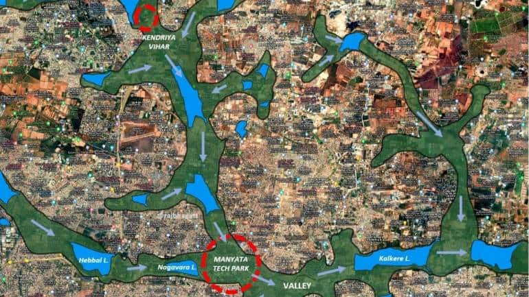 A map showing Hebbal valley in Bengaluru. We are building right in the middle of valleys.Read Tweets below to see how the areas marked in red were affected. (Credit: Raj Bhagat)Is topography an advantage or disadvantage?
“Bengaluru sits on top of a ridge and it is not supposed to flood as we see today,” Raj said. In coastal cities like Mumbai, concretised landscape, drainage, and, most importantly, climate change are contributing factors. In Chennai, lack of interconnectivity of wetlands is an important factor for flooding. Being on a higher elevation, Bengaluru saw a drastic change in the last two decades. Before 2000, we hardly saw any floods,” he added.
Bengaluru is located on undulated (rising and falling) terrain, with continuous valleys and ridges sprawling across the area. Three major valleys that make up the city are Hebbal Valley (207 sq km), Vrishabhavathi Valley (165 sq km) and Koramangala-Challaghatta Valley (255 sq km).
Experts say rapid urbanisation, coupled with a real-estate boom, has modified the major water canals and narrowed down the valleys, making them incapable of carrying excess water.
A study by Ramachandra shows that storm water drains connecting the Bellandur lake from the city market side have narrowed to 28.5 m against the original width of 60 m. With intense rainfall and an increase in paved surfaces, the woes will only rise. In fact, 78 percent of Bengaluru's land surface is paved.
Srinivasa said the existing stormwater drainage system has to be evaluated right from the micro-level. Researchers also say that stormwater drain capacities should be calculated by taking rainfall rates into account.
Will rainwater harvesting, building drains help?They can reduce the run-offs significantly, say researchers. “Bengaluru receives around 900 mm of rainfall per annum. By harvesting that, we get about 18,000 million cubic feet or 17 trillion cubic feet of water. If each person consumes 80 litres of water every day, it will be sufficient," Srinivasa said.
Additionally, the problem of floods due to constructions that violate buffer zones should be addressed through an appropriate combination of structural designs like watershed treatment where the channels carrying water to the tanks should be unobstructed and maintained properly, and non-structural methods like forewarning system and citizen awareness are implemented well, he suggested.
Lack of data leave researchers in limboIn the absence of any public data on the city's drainage structure, most researchers have failed to analyse the solution critically.
Dr. Indu K Murthy, Sector Head in the Climate, Environment and Sustainability team at Center for Study of Science, Technology and Policy, says every state has its own Climate Change Action Plan.
“However, we currently need an action plan taking at least 30 years of climate change projections on mind. There needs to be coordinated efforts to get academic researchers and government researchers on a single platform to integrate all suggestions and come up with an action plan,” she says.
It is not that suggestions and action plans haven’t been submitted.
“We have sent multiple reports to the government. In fact, two months back, I had personally submitted a report on flooding to the Karnataka CM. So far, no response has been received,” Ramachandra said.
"All data related to flooding, infrastructure, and monitoring stations should be open to the public. That hardly happens," he said.
What is the BBMP’s argument? “Publishing data will invite more criticism from the public. BBMP will make the data available to researchers upon request,” says Lokesh.
Discover the latest Business News, Sensex, and Nifty updates. Obtain Personal Finance insights, tax queries, and expert opinions on Moneycontrol or download the Moneycontrol App to stay updated!
Find the best of Al News in one place, specially curated for you every weekend.
Stay on top of the latest tech trends and biggest startup news.


